Trail Walking Guiler-sur-Goyen - Autour de Guiler-sur-Goyen - Photo

Autour de Guiler-sur-Goyen

 tracegps
tracegps

User

© OpenStreetMap contributors
Length
Length
14.9 km
Max alt
Max alt
124 m
Uphill gradient
Uphill gradient
234 m
Km-Effort
Km-Effort  
18 km
Min alt
Min alt
40 m
Downhill gradient
Downhill gradient
232 m
Boucle
Boucle
Yes
Creation date :
2014-12-11 00:00:00.0
Updated on :
2014-12-11 00:00:00.0

(0 Reviews)

Walking
Walking
3h45
Difficulty : Difficult

Scan this QR Code to open this trail in the SityTrail application

FREE GPS app for hiking

Logo SityTrail SityTrail

IGN / Geographical institutes

Download SityTrail from the App Store Download SityTrail from Google Play

Logo SityTrail SityTrail World

The world is yours!

Download SityTrail from the App Store Download SityTrail from Google Play Download SityTrail on Huawei AppGallery

About

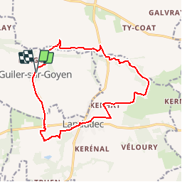
Trail Walking of 14.9 km to be discovered at Brittany, Finistère, Guiler-sur-Goyen. This trail is proposed by tracegps.

Description

Départ du parking de la Mairie de Guiler-sur-Goyen. Quittez le village par le Nord pour suivre « le Goyen » jusqu'à la carrière. Aprés celle-ci, tournez à gauche en direction du Moulin Corn, rattraper « le Goyen » A la route, tournez à droite sur 100m pour prendre un chemin vers Kerannor, puis Kerhat pour arriver à Landudec. Prendre la D784 pour tourner rapidement vers le sentier botanique. Au bout de la route prendre le chemin à droite. A la route, prendre à droite, où après avoir couper la D784, on rejoint le départ.

Elevation profile

Photos

Positioning

Country:
France
Region :
Brittany
Department/Province :
Finistère
Municipality :
Guiler-sur-Goyen
Location:
Unknown
Start:(UTM)
398727 ; 5319044 (30U) N.

Trails nearby

Trail Walking Landudec - LANDUDEC  - Photo
Walking
RonanDAGORN

Walking

Medium
Landudec, Brittany, Finistère, France
22 km | 26 km-effort
5h 1min
Yes
Trail Walking Landudec - landudec  - Photo
Walking
pascalgrondin

Walking

Very easy
Landudec, Brittany, Finistère, France
7.8 km | 9.1 km-effort
1h 42min
Yes
Trail Walking Landudec -  landudec - Photo
Walking
arremoulit

Walking

Difficult
Landudec, Brittany, Finistère, France
11.1 km | 12.9 km-effort
2h 14min
Yes
Trail Walking Plozévet - PLOZEVET  - Photo
Walking
RonanDAGORN

Walking

Medium
Plozévet, Brittany, Finistère, France
20 km | 24 km-effort
4h 42min
Yes
Trail Walking Landudec - landudec  - Photo
Walking
arremoulit

Walking

Difficult
Landudec, Brittany, Finistère, France
10.6 km | 12.3 km-effort
2h 7min
Yes
Trail Walking Plozévet - chapelle St ronan - Photo
Walking
arremoulit

Walking

Medium
Plozévet, Brittany, Finistère, France
10.1 km | 11.5 km-effort
2h 8min
Yes
Trail Hybrid bike Pouldergat - locronan - Photo
Hybrid bike
jpl27

Hybrid bike

Very difficult
Pouldergat, Brittany, Finistère, France
52 km | 61 km-effort
4h 25min
Yes
Trail Walking Plozévet - 0507020 - Photo
Walking
arremoulit

Walking

Very easy
Plozévet, Brittany, Finistère, France
10 km | 11.3 km-effort
2h 1min
No
Trail Walking Landudec - 13.10.19 - Photo
Walking
arremoulit

Walking

Very easy
Landudec, Brittany, Finistère, France
10.5 km | 12.4 km-effort
1h 53min
Yes


Close
My subscriptions