Trail Mountain bike Bazoches-au-Houlme - Lac de Rabodanges via Putanges - Bazoches au Houlme - Photo

Lac de Rabodanges via Putanges - Bazoches au Houlme

 tracegps
tracegps

User

© OpenStreetMap contributors
Length
Length
25 km
Max alt
Max alt
231 m
Uphill gradient
Uphill gradient
391 m
Km-Effort
Km-Effort  
30 km
Min alt
Min alt
123 m
Downhill gradient
Downhill gradient
392 m
Boucle
Boucle
Yes
Creation date :
2014-12-10 00:00:00.0
Updated on :
2014-12-10 00:00:00.0

(0 Reviews)

Mountain bike
Mountain bike
2h30
Difficulty : Medium

Scan this QR Code to open this trail in the SityTrail application

FREE GPS app for hiking

Logo SityTrail SityTrail

IGN / Geographical institutes

Download SityTrail from the App Store Download SityTrail from Google Play

Logo SityTrail SityTrail World

The world is yours!

Download SityTrail from the App Store Download SityTrail from Google Play Download SityTrail on Huawei AppGallery

About

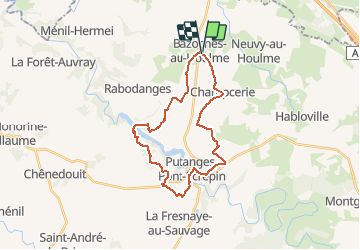
Trail Mountain bike of 25 km to be discovered at Normandy, Orne, Bazoches-au-Houlme. This trail is proposed by tracegps.

Description

En partant de Bazoches vous descendrez sur Putanges assis sur le granit en fond de vallée et puis vous passerez sur l'Orne et remonterez sur le Vieux Putanges. Aller en route pour le Lac, je dirais même la campagne qui le domine.

Elevation profile

Photos

Positioning

Country:
France
Region :
Normandy
Department/Province :
Orne
Municipality :
Bazoches-au-Houlme
Location:
Unknown
Start:(UTM)
702657 ; 5410714 (30U) N.

Trails nearby

Trail Mountain bike Bazoches-au-Houlme - Lac de Rabodanges via Giel-Courteilles - Bazoches-au-Houlme - Photo
Mountain bike
tracegps

Mountain bike

Difficult
Bazoches-au-Houlme, Normandy, Orne, France
42 km | 50 km-effort
4h 0min
Yes
Trail On foot La Hoguette - Circuit du Bois de Saint-André - Photo
On foot
PRO

On foot

Easy
La Hoguette, Normandy, Calvados, France
6.9 km | 8.4 km-effort
1h 54min
Yes
Trail Walking Putanges-le-Lac - les douze puits - Photo
Walking
duchemin

Walking

Very easy
Putanges-le-Lac, Normandy, Orne, France
10.2 km | 12 km-effort
2h 56min
Yes
Trail On foot La Hoguette - Circuit du Vivier - Photo
On foot
PRO

On foot

Easy
La Hoguette, Normandy, Calvados, France
7.8 km | 8.6 km-effort
1h 57min
Yes
Trail Coupling Putanges-le-Lac - rando aprem calèche rotourelle  - Photo
Coupling
Delphine Besace

Coupling

Very easy
Putanges-le-Lac, Normandy, Orne, France
24 km | 30 km-effort
3h 20min
No
Trail On foot Putanges-le-Lac - Les Gorges de St Aubert - Photo
On foot
michelberrier

On foot

Easy
Putanges-le-Lac, Normandy, Orne, France
10.1 km | 13.8 km-effort
3h 7min
Yes
Trail Quad Putanges-le-Lac - Lylian - Photo
Quad
lyorick

Quad

Putanges-le-Lac, Normandy, Orne, France
28 km | 35 km-effort
59min
Yes
Trail Road bike Putanges-le-Lac - RABODANGE BRIOUZE - Photo
Road bike
Schouller

Road bike

Very easy
Putanges-le-Lac, Normandy, Orne, France
16.4 km | 19.5 km-effort
18min
No
Trail Walking Putanges-le-Lac - autour de Rabodange - Photo
Walking
albers

Walking

Medium
Putanges-le-Lac, Normandy, Orne, France
22 km | 29 km-effort
5h 0min
Yes


Close
My subscriptions