Trail Cycle Foix - De Foix au lac de Montbel - Photo

De Foix au lac de Montbel

 tracegps
tracegps

User

© OpenStreetMap contributors
Length
Length
104 km
Max alt
Max alt
659 m
Uphill gradient
Uphill gradient
1489 m
Km-Effort
Km-Effort  
124 km
Min alt
Min alt
364 m
Downhill gradient
Downhill gradient
1488 m
Boucle
Boucle
Yes
Creation date :
2014-12-10 00:00:00.0
Updated on :
2014-12-10 00:00:00.0

(0 Reviews)

Cycle
Cycle
5h00
Difficulty : Difficult

Scan this QR Code to open this trail in the SityTrail application

FREE GPS app for hiking

Logo SityTrail SityTrail

IGN / Geographical institutes

Download SityTrail from the App Store Download SityTrail from Google Play

Logo SityTrail SityTrail World

The world is yours!

Download SityTrail from the App Store Download SityTrail from Google Play Download SityTrail on Huawei AppGallery

About

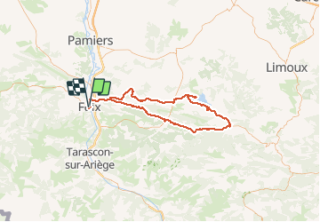
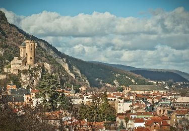
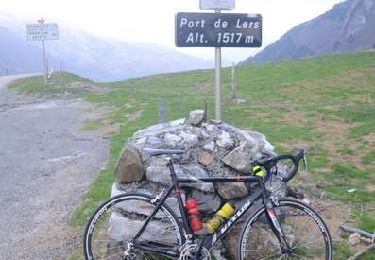
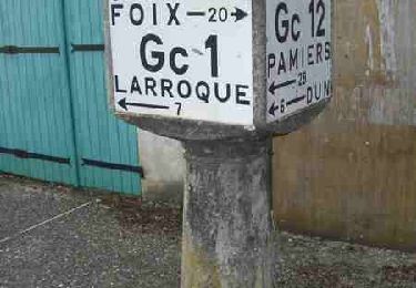
Trail Cycle of 104 km to be discovered at Occitania, Ariège, Foix. This trail is proposed by tracegps.

Description

Le circuit au départ du parking du cimetière de Foix, vous conduit à Lavelanet, Bélesta puis à Puivert où vous pouvez aller jusqu'à son lac. Ensuite direction Rivel, pour rejoindre Léran, où il faudra faire un aller retour pour rejoindre le barrage du lac de Montbel. Après Laroque-d'Olmes on rentre par Carla-de-Roquefort pour rattraper la D1 qui vous ramène au point de départ.

Elevation profile

Photos

Positioning

Country:
France
Region :
Occitania
Department/Province :
Ariège
Municipality :
Foix
Location:
Unknown
Start:(UTM)
386535 ; 4757539 (31T) N.

Trails nearby

Trail Walking Prayols - Cuminge  - Photo
Walking
David Girabet

Walking

Easy
(1)
Prayols, Occitania, Ariège, France
3.5 km | 6.1 km-effort
1h 0min
Yes
Trail Walking Foix - 01 - FOIX à ROQUEFIXADE - Chemin des Bons-Hommes GR107 GR367 - Photo
Walking
jopost

Walking

Difficult
Foix, Occitania, Ariège, France
18.6 km | 30 km-effort
6h 36min
No
Trail Walking Foix - pech de foix - Photo
Walking
christian425

Walking

Very easy
(1)
Foix, Occitania, Ariège, France
7.5 km | 13.6 km-effort
3h 43min
Yes
Trail Cycle Foix - A vélo en Basse Ariège - Foix - Photo
Cycle
tracegps

Cycle

Medium
Foix, Occitania, Ariège, France
97 km | 111 km-effort
4h 49min
Yes
Trail Cycle Foix - Port de Lers - Foix - Photo
Cycle
tracegps

Cycle

Difficult
Foix, Occitania, Ariège, France
115 km | 152 km-effort
6h 7min
Yes
Trail Cycle Foix - Sortie cyclo vers Mirepoix - Photo
Cycle
tracegps

Cycle

Medium
Foix, Occitania, Ariège, France
81 km | 94 km-effort
3h 4min
Yes
Trail Cycle Foix - De Foix à Montségur - Photo
Cycle
tracegps

Cycle

Difficult
Foix, Occitania, Ariège, France
87 km | 109 km-effort
4h 13min
Yes
Trail Cycle Foix - Rhodes le Bas - Foix - Photo
Cycle
tracegps

Cycle

Medium
Foix, Occitania, Ariège, France
75 km | 89 km-effort
2h 45min
Yes
Trail Cycle Foix - De Foix à Lavelanet par Roquefixade - Photo
Cycle
tracegps

Cycle

Medium
Foix, Occitania, Ariège, France
50 km | 60 km-effort
2h 0min
Yes


Close
My subscriptions