Trail Mountain bike Cires-lès-Mello - Cires-lès-Mello, coté Ouest - Photo

Cires-lès-Mello, coté Ouest

 tracegps
tracegps

User

© OpenStreetMap contributors
Length
Length
58 km
Max alt
Max alt
238 m
Uphill gradient
Uphill gradient
813 m
Km-Effort
Km-Effort  
69 km
Min alt
Min alt
36 m
Downhill gradient
Downhill gradient
813 m
Boucle
Boucle
Yes
Creation date :
2014-12-10 00:00:00.0
Updated on :
2014-12-10 00:00:00.0

(0 Reviews)

Mountain bike
Mountain bike
3h30
Difficulty : Medium

Scan this QR Code to open this trail in the SityTrail application

FREE GPS app for hiking

Logo SityTrail SityTrail

IGN / Geographical institutes

Download SityTrail from the App Store Download SityTrail from Google Play

Logo SityTrail SityTrail World

The world is yours!

Download SityTrail from the App Store Download SityTrail from Google Play Download SityTrail on Huawei AppGallery

About

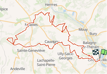
Trail Mountain bike of 58 km to be discovered at Hauts-de-France, Oise, Cires-lès-Mello. This trail is proposed by tracegps.

Description

Boucle VTT, au départ de l'église de Cires-lès-Mello.
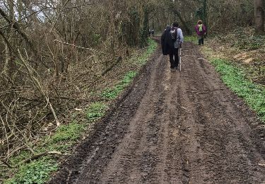
Elevation profile

Photos

Positioning

Country:
France
Region :
Hauts-de-France
Department/Province :
Oise
Municipality :
Cires-lès-Mello
Location:
Unknown
Start:(UTM)
453395 ; 5458237 (31U) N.

Trails nearby

Trail Walking Bury - Bury_Trace GPS_8,9 km - Photo
Walking
Pousscailleux

Walking

Medium
(1)
Bury, Hauts-de-France, Oise, France
8.9 km | 11.1 km-effort
2h 25min
Yes
Trail Walking Saint-Vaast-lès-Mello - 18 randonnée des carrières  - Photo
Walking
fitz2014

Walking

Difficult
Saint-Vaast-lès-Mello, Hauts-de-France, Oise, France
11 km | 12.9 km-effort
2h 49min
Yes
Trail Walking Cires-lès-Mello - Cires les Mello - Photo
Walking
Francine

Walking

Medium
Cires-lès-Mello, Hauts-de-France, Oise, France
12.7 km | 15.4 km-effort
3h 20min
Yes
Trail Walking Cires-lès-Mello - Cires les Mello - Photo
Walking
Francine

Walking

Medium
Cires-lès-Mello, Hauts-de-France, Oise, France
12.7 km | 15.4 km-effort
3h 20min
Yes
Trail Nordic walking Montataire - Montataire 2 - Photo
Nordic walking
Francine

Nordic walking

Medium
Montataire, Hauts-de-France, Oise, France
10.7 km | 12.5 km-effort
2h 40min
Yes
Trail Nordic walking Montataire - Montataire 12k100 - Photo
Nordic walking
Francine

Nordic walking

Medium
Montataire, Hauts-de-France, Oise, France
11.7 km | 14.3 km-effort
2h 0min
Yes
Trail Nordic walking Montataire - Montataire 12k100 - Photo
Nordic walking
Francine

Nordic walking

Medium
Montataire, Hauts-de-France, Oise, France
11.8 km | 14.3 km-effort
2h 0min
Yes
Trail Nordic walking Montataire - montataire - Photo
Nordic walking
Francine

Nordic walking

Easy
Montataire, Hauts-de-France, Oise, France
12.1 km | 14.5 km-effort
2h 0min
Yes
Trail Walking Ercuis - Ercuis  - Photo
Walking
Djaie60

Walking

Easy
Ercuis, Hauts-de-France, Oise, France
13.3 km | 15.7 km-effort
3h 0min
Yes


Close
My subscriptions