


cote corbeile

flux99
User
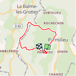

Length
5.6 km

Max alt
354 m

Uphill gradient
113 m
Km-Effort
7.1 km

Min alt
271 m

Downhill gradient
113 m
Boucle
Yes
Creation date :
2014-12-10 00:00:00.0
Updated on :
2014-12-10 00:00:00.0
1h32
Difficulty : Very easy

FREE GPS app for hiking
 SityTrail
IGN / Geographical institutes
SityTrail Plus
The world is yours!
About
Trail Walking of 5.6 km to be discovered at Auvergne-Rhône-Alpes, Isère, Parmilieu. This trail is proposed by flux99.
Description
par la source des anes
Positioning
Country:
France
Region :
Auvergne-Rhône-Alpes
Department/Province :
Isère
Municipality :
Parmilieu
Location:
Unknown
Start:(Dec)
Start:(UTM)
682216 ; 5078310 (31T) N.
Comments