


les deux vierges

xav34830
User
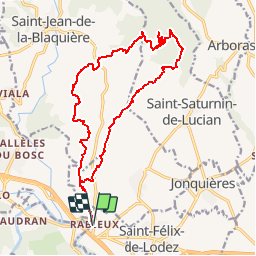

Length
19.4 km

Max alt
521 m

Uphill gradient
547 m
Km-Effort
27 km

Min alt
74 m

Downhill gradient
544 m
Boucle
Yes
Creation date :
2014-12-10 00:00:00.0
Updated on :
2014-12-10 00:00:00.0
7h00
Difficulty : Medium

FREE GPS app for hiking
 SityTrail
IGN / Geographical institutes
SityTrail Plus
The world is yours!
About
Trail Walking of 19.4 km to be discovered at Occitania, Hérault, Ceyras. This trail is proposed by xav34830.
Positioning
Country:
France
Region :
Occitania
Department/Province :
Hérault
Municipality :
Ceyras
Location:
Unknown
Start:(Dec)
Start:(UTM)
535330 ; 4834855 (31T) N.
Comments
Nulle dangereuse chemin introuvable ou impraticable à surtout ne pas faire
belle rando faite en 7h 30 avec pauses.photos repas...faite le 21/01/18 a noter que nous avons eu de la chance d être dans une année sèche car a l aller nous marchons longtemps dans le lit de la rivière c est magnifique mais s il y a trop d eau c est parfois difficile a contourner car épineux...au retour présence d un immense enclos avec chevaux donc nous avons contourné en allant jusqu'au pont de la route puis avons rejoint chemins de l aller.beau circuit piste au retour et hors sentier a l aller avec un peu de recherche sympa