


vers Finhaut

fpitance
User
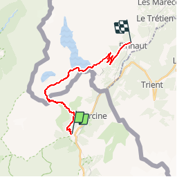

Length
22 km

Max alt
2639 m

Uphill gradient
1411 m
Km-Effort
40 km

Min alt
1346 m

Downhill gradient
1437 m
Boucle
No
Creation date :
2014-12-10 00:00:00.0
Updated on :
2014-12-10 00:00:00.0
5h00
Difficulty : Medium

FREE GPS app for hiking
 SityTrail
IGN / Geographical institutes
SityTrail Plus
The world is yours!
About
Trail Winter sports of 22 km to be discovered at Auvergne-Rhône-Alpes, Upper Savoy, Vallorcine. This trail is proposed by fpitance.
Description
Du couteray à finhaut par le barrage d'emosson
Positioning
Country:
France
Region :
Auvergne-Rhône-Alpes
Department/Province :
Upper Savoy
Municipality :
Vallorcine
Location:
Unknown
Start:(Dec)
Start:(UTM)
338653 ; 5098608 (32T) N.
Comments