


Randoguide

ray05
User

Length
10.9 km

Max alt
122 m

Uphill gradient
164 m
Km-Effort
13.1 km

Min alt
61 m

Downhill gradient
163 m
Boucle
Yes
Creation date :
2014-12-10 00:00:00.0
Updated on :
2014-12-10 00:00:00.0
--
Difficulty : Unknown

FREE GPS app for hiking
 SityTrail
IGN / Geographical institutes
SityTrail Plus
The world is yours!
About
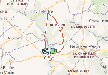
Trail Other activity of 10.9 km to be discovered at Ile-de-France, Val-d'Oise, Chars. This trail is proposed by ray05.
Positioning
Country:
France
Region :
Ile-de-France
Department/Province :
Val-d'Oise
Municipality :
Chars
Location:
Unknown
Start:(Dec)
Start:(UTM)
422531 ; 5445836 (31U) N.
Comments