


mont cauvaire

nathycandy
User
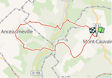

Length
9.4 km

Max alt
175 m

Uphill gradient
223 m
Km-Effort
12.4 km

Min alt
62 m

Downhill gradient
222 m
Boucle
Yes
Creation date :
2014-12-10 00:00:00.0
Updated on :
2014-12-10 00:00:00.0
2h40
Difficulty : Easy

FREE GPS app for hiking
 SityTrail
IGN / Geographical institutes
SityTrail Plus
The world is yours!
About
Trail Walking of 9.4 km to be discovered at Normandy, Seine-Maritime, Mont-Cauvaire. This trail is proposed by nathycandy.
Positioning
Country:
France
Region :
Normandy
Department/Province :
Seine-Maritime
Municipality :
Mont-Cauvaire
Location:
Unknown
Start:(Dec)
Start:(UTM)
363223 ; 5492809 (31U) N.
Comments