


Merindol Font de l'Orme

mhetpierre
User
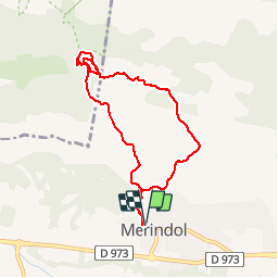

Length
9.6 km

Max alt
333 m

Uphill gradient
253 m
Km-Effort
12.9 km

Min alt
168 m

Downhill gradient
254 m
Boucle
Yes
Creation date :
2018-08-18 15:31:20.139
Updated on :
2018-08-18 15:31:20.139
2h45
Difficulty : Medium

FREE GPS app for hiking
 SityTrail
IGN / Geographical institutes
SityTrail Plus
The world is yours!
About
Trail Walking of 9.6 km to be discovered at Provence-Alpes-Côte d'Azur, Vaucluse, Mérindol. This trail is proposed by mhetpierre.
Description
vzudois
Positioning
Country:
France
Region :
Provence-Alpes-Côte d'Azur
Department/Province :
Vaucluse
Municipality :
Mérindol
Location:
Unknown
Start:(Dec)
Start:(UTM)
677213 ; 4847154 (31T) N.
Comments