


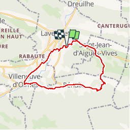
09 Lavelanet Benaix Villeneuve

RR31
User

Length
14.7 km

Max alt
635 m

Uphill gradient
240 m
Km-Effort
17.9 km

Min alt
502 m

Downhill gradient
239 m
Boucle
Yes
Creation date :
2014-12-10 00:00:00.0
Updated on :
2014-12-10 00:00:00.0
3h47
Difficulty : Easy

FREE GPS app for hiking
 SityTrail
IGN / Geographical institutes
SityTrail Plus
The world is yours!
About
Trail Walking of 14.7 km to be discovered at Occitania, Ariège, Lavelanet. This trail is proposed by RR31.
Description
Tour par la route Lavelanet Benaix Villeneuve d'olmes pour tester Sity Trail sur IPhone et intégration sur le portail Sity
Positioning
Country:
France
Region :
Occitania
Department/Province :
Ariège
Municipality :
Lavelanet
Location:
Unknown
Start:(Dec)
Start:(UTM)
406255 ; 4753238 (31T) N.
Comments