


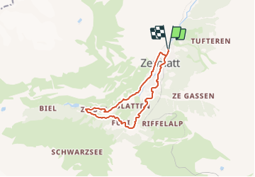
Zermatt - In den Bach

heinzwei
User

Length
11.2 km

Max alt
1962 m

Uphill gradient
420 m
Km-Effort
16.8 km

Min alt
1593 m

Downhill gradient
419 m
Boucle
Yes
Creation date :
2014-12-10 00:00:00.0
Updated on :
2014-12-10 00:00:00.0
4h00
Difficulty : Easy

FREE GPS app for hiking
 SityTrail
IGN / Geographical institutes
SityTrail Plus
The world is yours!
About
Trail Other activity of 11.2 km to be discovered at Valais/Wallis, Visp, Zermatt. This trail is proposed by heinzwei.
Description
Parcours fait le 15.02.2013, par un temps nuageux avec petites chutes de neige.
Journée idyllique malgré le temps gris
Positioning
Country:
Switzerland
Region :
Valais/Wallis
Department/Province :
Visp
Municipality :
Zermatt
Location:
Unknown
Start:(Dec)
Start:(UTM)
403518 ; 5097768 (32T) N.
Comments