Le colignon

yoyodutheil
User
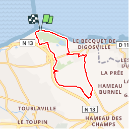

Length
5.8 km

Max alt
102 m

Uphill gradient
112 m
Km-Effort
7.2 km

Min alt
0 m

Downhill gradient
111 m
Boucle
Yes
Creation date :
2014-12-10 00:00:00.0
Updated on :
2014-12-10 00:00:00.0
1h34
Difficulty : Unknown

FREE GPS app for hiking
 SityTrail
IGN / Geographical institutes
SityTrail Plus
The world is yours!
About
Trail Walking of 5.8 km to be discovered at Normandy, Manche, Cherbourg-en-Cotentin. This trail is proposed by yoyodutheil.
Positioning
Country:
France
Region :
Normandy
Department/Province :
Manche
Municipality :
Cherbourg-en-Cotentin
Location:
Tourlaville
Start:(Dec)
Start:(UTM)
603317 ; 5501439 (30U) N.
Comments