


30km - printemps

kmikzf
User

Length
34 km

Max alt
140 m

Uphill gradient
322 m
Km-Effort
39 km

Min alt
98 m

Downhill gradient
319 m
Boucle
Yes
Creation date :
2014-12-10 00:00:00.0
Updated on :
2014-12-10 00:00:00.0
1h00
Difficulty : Unknown

FREE GPS app for hiking
 SityTrail
IGN / Geographical institutes
SityTrail Plus
The world is yours!
About
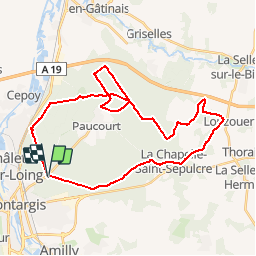
Trail Other activity of 34 km to be discovered at Centre-Loire Valley, Loiret, Chalette-sur-Loing. This trail is proposed by kmikzf.


Positioning
Country:
France
Region :
Centre-Loire Valley
Department/Province :
Loiret
Municipality :
Chalette-sur-Loing
Location:
Unknown
Start:(Dec)
Start:(UTM)
482107 ; 5317625 (31U) N.
Comments