


CARNAC NORD

rousseau.mich
User
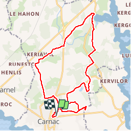

Length
19 km

Max alt
34 m

Uphill gradient
169 m
Km-Effort
21 km

Min alt
1 m

Downhill gradient
173 m
Boucle
Yes
Creation date :
2014-12-10 00:00:00.0
Updated on :
2014-12-10 00:00:00.0
4h40
Difficulty : Medium

FREE GPS app for hiking
 SityTrail
IGN / Geographical institutes
SityTrail Plus
The world is yours!
About
Trail Walking of 19 km to be discovered at Brittany, Morbihan, Carnac. This trail is proposed by rousseau.mich.
Positioning
Country:
France
Region :
Brittany
Department/Province :
Morbihan
Municipality :
Carnac
Location:
Unknown
Start:(Dec)
Start:(UTM)
494466 ; 5270323 (30T) N.
Comments