


TMB - Etape 7
© OpenStreetMap contributors


5h58
Difficulty : Difficult


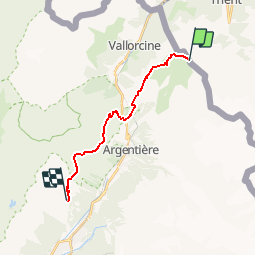
Length
14 km
Max alt
2359 m
Uphill gradient
1168 m
Km-Effort
31 km
Min alt
1439 m
Downhill gradient
1488 m
Boucle
No
Creation date :
2016-03-09 00:00:00.0
Updated on :
2016-03-09 00:00:00.0
5h58
Difficulty : Difficult
FREE GPS app for hiking
 SityTrail
IGN / Geographical institutes
SityTrail Plus
The world is yours!
About
Trail Walking of 14 km to be discovered at Valais/Wallis, Martigny, Trient. This trail is proposed by maxime.ranchin@aliceadsl.fr.
Positioning
Country:
Switzerland
Region :
Valais/Wallis
Department/Province :
Martigny
Municipality :
Trient
Location:
Unknown
Start:(Dec)
Start:(UTM)
342902 ; 5099030 (32T) N.
Comments