


raissac

RR31
User
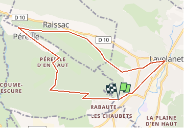

Length
10.8 km

Max alt
792 m

Uphill gradient
319 m
Km-Effort
15.1 km

Min alt
527 m

Downhill gradient
322 m
Boucle
Yes
Creation date :
2014-12-10 00:00:00.0
Updated on :
2014-12-10 00:00:00.0
2h30
Difficulty : Unknown

FREE GPS app for hiking
 SityTrail
IGN / Geographical institutes
SityTrail Plus
The world is yours!
About
Trail Walking of 10.8 km to be discovered at Occitania, Ariège, Lavelanet. This trail is proposed by RR31.
Positioning
Country:
France
Region :
Occitania
Department/Province :
Ariège
Municipality :
Lavelanet
Location:
Unknown
Start:(Dec)
Start:(UTM)
404716 ; 4752945 (31T) N.
Comments