grotte beaumaniere methamis

d.jeanjean
User
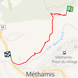

Length
1.2 km

Max alt
353 m

Uphill gradient
14 m
Km-Effort
1.6 km

Min alt
263 m

Downhill gradient
82 m
Boucle
No
Creation date :
2014-12-10 00:00:00.0
Updated on :
2014-12-10 00:00:00.0
21m
Difficulty : Easy

FREE GPS app for hiking
 SityTrail
IGN / Geographical institutes
SityTrail Plus
The world is yours!
About
Trail Walking of 1.2 km to be discovered at Provence-Alpes-Côte d'Azur, Vaucluse, Méthamis. This trail is proposed by d.jeanjean.
Description
départ avant le pont sur la Nesque sur la route a gauche
Positioning
Country:
France
Region :
Provence-Alpes-Côte d'Azur
Department/Province :
Vaucluse
Municipality :
Méthamis
Location:
Unknown
Start:(Dec)
Start:(UTM)
678363 ; 4876437 (31T) N.
Comments