


GR70_LeAlpiers-LePont-de-Montvert

svp59
User
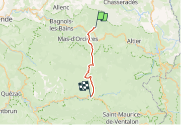

Length
22 km

Max alt
1699 m

Uphill gradient
666 m
Km-Effort
32 km

Min alt
890 m

Downhill gradient
952 m
Boucle
No
Creation date :
2014-12-10 00:00:00.0
Updated on :
2014-12-10 00:00:00.0
6h33
Difficulty : Medium

FREE GPS app for hiking
 SityTrail
IGN / Geographical institutes
SityTrail Plus
The world is yours!
About
Trail Walking of 22 km to be discovered at Occitania, Lozère, Cubières. This trail is proposed by svp59.
Positioning
Country:
France
Region :
Occitania
Department/Province :
Lozère
Municipality :
Cubières
Location:
Unknown
Start:(Dec)
Start:(UTM)
560174 ; 4927781 (31T) N.
Comments