


Toulouse St Jean

RR31
User

Length
18.1 km

Max alt
211 m

Uphill gradient
186 m
Km-Effort
20 km

Min alt
121 m

Downhill gradient
128 m
Boucle
No
Creation date :
2014-12-10 00:00:00.0
Updated on :
2014-12-10 00:00:00.0
4h28
Difficulty : Easy

FREE GPS app for hiking
 SityTrail
IGN / Geographical institutes
SityTrail Plus
The world is yours!
About
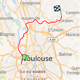
Trail Walking of 18.1 km to be discovered at Occitania, Haute-Garonne, Toulouse. This trail is proposed by RR31.
Description
de Toulouse Zenith à St Jean par garonne rive droite - canal garonne - Aucamville- Launaguet - L'Union - St Jean L'Union


Positioning
Country:
France
Region :
Occitania
Department/Province :
Haute-Garonne
Municipality :
Toulouse
Location:
Unknown
Start:(Dec)
Start:(UTM)
371553 ; 4828111 (31T) N.
Comments