


Monte Lema

Dgubler
User


--
Difficulty : Unknown

FREE GPS app for hiking
 SityTrail
IGN / Geographical institutes
SityTrail Plus
The world is yours!
About
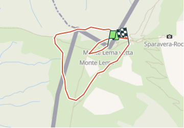
Trail Other activity of 1.9 km to be discovered at Ticino, Distretto di Lugano, Miglieglia. This trail is proposed by Dgubler.
Description
Randonnée facile d''environ une heure autour d''un sommet à la frontière helveto-italienne (le Monte Lema lui-même s''atteint en téléphérique). Nous l''avons fait le 12 août 2005.
Easy one-hour hike around the top of Monte Lema at the Swiss-Italian border.
Positioning
Comments