Trail Other activity Onsernone - Munzelüm - Photo
 Dgubler
Dgubler

User

© OpenStreetMap contributors
Length
Length
2.2 km
Max alt
Max alt
2047 m
Uphill gradient
Uphill gradient
1 m
Km-Effort
Km-Effort  
3.2 km
Min alt
Min alt
1762 m
Downhill gradient
Downhill gradient
274 m
Boucle
Boucle
No
Creation date :
2014-12-11 00:00:00.0
Updated on :
2014-12-11 00:00:00.0

(0 Reviews)

Other activity
Other activity
--
Difficulty : Unknown

Scan this QR Code to open this trail in the SityTrail application

FREE GPS app for hiking

Logo SityTrail SityTrail

IGN / Geographical institutes

Download SityTrail from the App Store Download SityTrail from Google Play

Logo SityTrail SityTrail Plus

The world is yours!

Download SityTrail from the App Store Download SityTrail from Google Play Download SityTrail on Huawei AppGallery

About

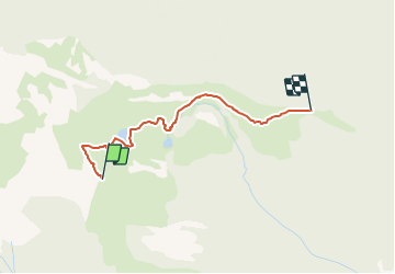
Trail Other activity of 2.2 km to be discovered at Ticino, Distretto di Locarno, Onsernone. This trail is proposed by Dgubler.

Description

Sommet près du lac de Salei dans le Val Onsernone. Part de la station supérieure d''un téléphérique au départ de Vergelletto. Daniel y est allé avec Françoise et Luca, le 7 août 2005 Grimpe facile... mais grimpe quand même! (NB: la route est indiquée dans le sens de la descente!)

Easy rock climbing of Munzelüm in Val Onsernone.

Elevation profile

Positioning

Country:
Switzerland
Region :
Ticino
Department/Province :
Distretto di Locarno
Municipality :
Onsernone
Location:
Unknown
Start:(UTM)
465278 ; 5118382 (32T) N.


Close
My subscriptions