Trail Walking Unknown - french island - Photo
 phidge
phidge

User

© OpenStreetMap contributors
Length
Length
14.3 km
Max alt
Max alt
55 m
Uphill gradient
Uphill gradient
115 m
Km-Effort
Km-Effort  
15.8 km
Min alt
Min alt
0 m
Downhill gradient
Downhill gradient
103 m
Boucle
Boucle
No
Creation date :
2019-01-20 16:37:21.151
Updated on :
2019-01-20 16:37:21.205

(0 Reviews)

Walking
Walking
3h29
Difficulty : Easy

Scan this QR Code to open this trail in the SityTrail application

FREE GPS app for hiking

Logo SityTrail SityTrail

IGN / Geographical institutes

Download SityTrail from the App Store Download SityTrail from Google Play

Logo SityTrail SityTrail World

The world is yours!

Download SityTrail from the App Store Download SityTrail from Google Play Download SityTrail on Huawei AppGallery

About

Trail Walking of 14.3 km to be discovered at Victoria. This trail is proposed by phidge.

Description

Peu d'interet, pas d'acces a la mer, chemins longs, rectilignes surtout la route finale. Peu de faune, sauf serpents ecrasses, plus un vrai Koala vivant dans un arbre, a l'arrivee a la maison d'hote pas loin de la jetee.
         

Elevation profile

Positioning

Country:
Australia
Region :
Victoria
Department/Province :
Unknown
Municipality :
Unknown
Location:
Unknown
Start:(UTM)
348999 ; 5750270 (55H) S.

Trails nearby

Trail Walking  - point leo - Photo
Walking
ARPF

Walking

Easy
(1)
, Victoria, Shire of Mornington Peninsula, Australia
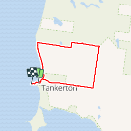
3.8 km | 4.3 km-effort
1h 39min
No
Trail Walking  - Balcombe estuary - Photo
Walking
phidge

Walking

Easy
, Victoria, Shire of Mornington Peninsula, Australia
13.2 km | 14.7 km-effort
5h 12min
Yes


Close
My subscriptions