


Rando île ste marguerite

LUTATIS
User
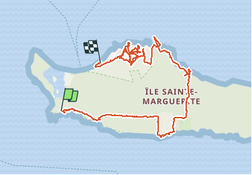

Length
6.3 km

Max alt
38 m

Uphill gradient
129 m
Km-Effort
8 km

Min alt
0 m

Downhill gradient
127 m
Boucle
No
Creation date :
2014-12-10 00:00:00.0
Updated on :
2014-12-10 00:00:00.0
2h51
Difficulty : Very easy

FREE GPS app for hiking
 SityTrail
IGN / Geographical institutes
SityTrail Plus
The world is yours!
About
Trail Walking of 6.3 km to be discovered at Provence-Alpes-Côte d'Azur, Maritime Alps, Cannes. This trail is proposed by LUTATIS.
Positioning
Country:
France
Region :
Provence-Alpes-Côte d'Azur
Department/Province :
Maritime Alps
Municipality :
Cannes
Location:
Unknown
Start:(Dec)
Start:(UTM)
341252 ; 4820241 (32T) N.
Comments