Trail Walking Carqueiranne - vlt 1000j Fête de la Rando 2013 Circuit Jaune - Photo

vlt 1000j Fête de la Rando 2013 Circuit Jaune

© OpenStreetMap contributors
Length
Length
13.4 km
Max alt
Max alt
213 m
Uphill gradient
Uphill gradient
385 m
Km-Effort
Km-Effort  
18.5 km
Min alt
Min alt
0 m
Downhill gradient
Downhill gradient
385 m
Boucle
Boucle
Yes
Creation date :
2014-12-10 00:00:00.0
Updated on :
2021-01-12 17:24:22.625

(0 Reviews)

Walking
Walking
4h02
Difficulty : Easy

Scan this QR Code to open this trail in the SityTrail application

FREE GPS app for hiking

Logo SityTrail SityTrail

IGN / Geographical institutes

Download SityTrail from the App Store Download SityTrail from Google Play

Logo SityTrail SityTrail Plus

The world is yours!

Download SityTrail from the App Store Download SityTrail from Google Play Download SityTrail on Huawei AppGallery

About

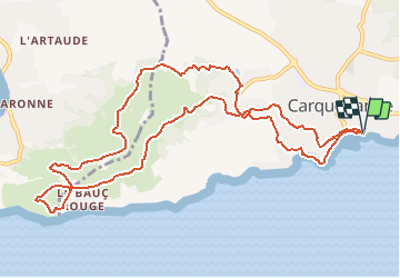
Trail Walking of 13.4 km to be discovered at Provence-Alpes-Côte d'Azur, Var, Carqueiranne. This trail is proposed by jmheydorff.

Description

départ Pins Penchés (proche Port de Carqueiranne)
parking à l'entrée ESt de Carqueiranne, sur la RD 559, en venant de l'Almanarre
Nota: depuis Hyères, ne pas suivre les GPS qui font passer par la RD 276 et le ch. du Col de Serre (route étroite et 2 virages très serrés).

Elevation profile

Positioning

Country:
France
Region :
Provence-Alpes-Côte d'Azur
Department/Province :
Var
Municipality :
Carqueiranne
Location:
Unknown
Start:(UTM)
262344 ; 4774685 (32T) N.


Close
My subscriptions