


Montpellier - Montarnaud

RR31
User
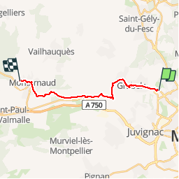

Length
17.8 km

Max alt
160 m

Uphill gradient
275 m
Km-Effort
21 km

Min alt
55 m

Downhill gradient
223 m
Boucle
No
Creation date :
2014-12-10 00:00:00.0
Updated on :
2014-12-10 00:00:00.0
--
Difficulty : Medium

FREE GPS app for hiking
 SityTrail
IGN / Geographical institutes
SityTrail Plus
The world is yours!
About
Trail Walking of 17.8 km to be discovered at Occitania, Hérault, Grabels. This trail is proposed by RR31.
Description
St Jacques
Photos


Positioning
Country:
France
Region :
Occitania
Department/Province :
Hérault
Municipality :
Grabels
Location:
Unknown
Start:(Dec)
Start:(UTM)
566386 ; 4832624 (31T) N.
Comments