


parcours du coeur feignies

pseudokool
User
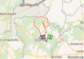

Length
10.1 km

Max alt
160 m

Uphill gradient
50 m
Km-Effort
10.7 km

Min alt
138 m

Downhill gradient
50 m
Boucle
Yes
Creation date :
2014-12-10 00:00:00.0
Updated on :
2014-12-10 00:00:00.0
1h40
Difficulty : Easy

FREE GPS app for hiking
 SityTrail
IGN / Geographical institutes
SityTrail Plus
The world is yours!
About
Trail Walking of 10.1 km to be discovered at Hauts-de-France, Nord, Feignies. This trail is proposed by pseudokool.
Description
2013
Positioning
Country:
France
Region :
Hauts-de-France
Department/Province :
Nord
Municipality :
Feignies
Location:
Unknown
Start:(Dec)
Start:(UTM)
565808 ; 5571646 (31U) N.
Comments