


Castres - Dourgne

RR31
User
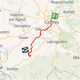

Length
25 km

Max alt
263 m

Uphill gradient
360 m
Km-Effort
30 km

Min alt
161 m

Downhill gradient
302 m
Boucle
No
Creation date :
2014-12-10 00:00:00.0
Updated on :
2014-12-10 00:00:00.0
--
Difficulty : Medium

FREE GPS app for hiking
 SityTrail
IGN / Geographical institutes
SityTrail Plus
The world is yours!
About
Trail Walking of 25 km to be discovered at Occitania, Tarn, Castres. This trail is proposed by RR31.
Description
St Jacques
Photos


26 photos in total. Please click on a photo to see them all in the gallery.
Positioning
Country:
France
Region :
Occitania
Department/Province :
Tarn
Municipality :
Castres
Location:
Unknown
Start:(Dec)
Start:(UTM)
438484 ; 4827769 (31T) N.
Comments