


ALAIRAC

CANON2
User
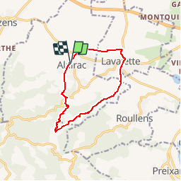

Length
11.1 km

Max alt
317 m

Uphill gradient
218 m
Km-Effort
14 km

Min alt
160 m

Downhill gradient
216 m
Boucle
Yes
Creation date :
2019-05-15 13:10:04.38
Updated on :
2019-05-15 13:10:04.468
3h02
Difficulty : Easy

FREE GPS app for hiking
 SityTrail
IGN / Geographical institutes
SityTrail Plus
The world is yours!
About
Trail Walking of 11.1 km to be discovered at Occitania, Aude, Alairac. This trail is proposed by CANON2.
Positioning
Country:
France
Region :
Occitania
Department/Province :
Aude
Municipality :
Alairac
Location:
Unknown
Start:(Dec)
Start:(UTM)
438363 ; 4781519 (31T) N.
Comments
Des asperges sauvages en chemin