Trail Other activity Formazza - Entre Tessin et Valais - Etape 4/4 - Photo

Entre Tessin et Valais - Etape 4/4

 Romrando
Romrando

User

© OpenStreetMap contributors
Length
Length
18.2 km
Max alt
Max alt
2598 m
Uphill gradient
Uphill gradient
810 m
Km-Effort
Km-Effort  
32 km
Min alt
Min alt
1400 m
Downhill gradient
Downhill gradient
1589 m
Boucle
Boucle
No
Creation date :
2014-12-11 00:00:00.0
Updated on :
2014-12-11 00:00:00.0

(0 Reviews)

Other activity
Other activity
--
Difficulty : Unknown

Scan this QR Code to open this trail in the SityTrail application

FREE GPS app for hiking

Logo SityTrail SityTrail

IGN / Geographical institutes

Download SityTrail from the App Store Download SityTrail from Google Play

Logo SityTrail SityTrail World

The world is yours!

Download SityTrail from the App Store Download SityTrail from Google Play Download SityTrail on Huawei AppGallery

About

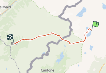
Trail Other activity of 18.2 km to be discovered at Piemont, Verbano-Cusio-Ossola, Formazza. This trail is proposed by Romrando.

Description

Source:geocities.com/romrando - 1.8.05

4ème étape

De la cabane A. Vannino on peut suivre directement la rive ouest du lac. Il est toutefois plus intéressant de remonter vers l''ouest pour rejoindre le petit lac Sruer puis vers le SW par une traversée et une petite redescente on rejoint le chemin venant du lac Vannino.

Par une marche ascendante vers le SW on atteint le col "Scatta Minoia" et son bivouac.

Une courte descente puis un vallon nous amène bientôt à une croisée des chemins. Prendre à droite vers le N, vers la bergerie "A. Forno inférieur". On poursuit dans la même direction puis 500 m plus loin on grimpe sur la gauche et on suit le chemin qui mène à un premier collet puis après une traversée une nouvelle montée mène directement à l''Albrunpass.

De là on gagne très vite au-dessous la cabane Binntal puis par le vallon du même nom et par une longue descente on rejoint le village de Binn. (Le car postal vous ramène alors dans la vallée de Conches.

Elevation profile

Positioning

Country:
Italy
Region :
Piemont
Department/Province :
Verbano-Cusio-Ossola
Municipality :
Formazza
Location:
Unknown
Start:(UTM)
451186 ; 5137043 (32T) N.

Trails nearby

Trail On foot Formazza - (SI E62) Rifugio Eugenio Margaroli all'Alpe Vannino - Bosco Gurin - Photo
On foot
PRO

On foot

Difficult
Formazza, Piemont, Verbano-Cusio-Ossola, Italy
21 km | 40 km-effort
8h 59min
No
Trail Walking Formazza - walser_11 - Photo
Walking
GUIDE+

Walking

Very easy
Formazza, Piemont, Verbano-Cusio-Ossola, Italy
8.1 km | 23 km-effort
Unknown
No
Trail Walking Formazza - walser_10b - Photo
Walking
GUIDE+

Walking

Very easy
Formazza, Piemont, Verbano-Cusio-Ossola, Italy
37 km | 60 km-effort
Unknown
No
Trail Other activity Formazza - Walser 3 - Photo
Other activity
pierrepraz

Other activity

Very easy
Formazza, Piemont, Verbano-Cusio-Ossola, Italy
12.8 km | 24 km-effort
Unknown
No
Trail Walking Formazza - Alpe Devero - Cascate del Toce - Photo
Walking
Allegro

Walking

Very easy
Formazza, Piemont, Verbano-Cusio-Ossola, Italy
24 km | 42 km-effort
9h 44min
No
Trail Other activity Formazza - Wallis ins Tessin 3. Tag Route Variante A - Photo
Other activity
U106659

Other activity

Very easy
Formazza, Piemont, Verbano-Cusio-Ossola, Italy
17.9 km | 33 km-effort
Unknown
No
Trail Other activity Formazza - Wallis ins Tessin 3. Tag - Photo
Other activity
U106659

Other activity

Very easy
Formazza, Piemont, Verbano-Cusio-Ossola, Italy
16.1 km | 34 km-effort
Unknown
No
Trail Other activity Formazza - Maria-Louisa Della creste - Photo
Other activity
U106659

Other activity

Very easy
Formazza, Piemont, Verbano-Cusio-Ossola, Italy
2 km | 6.2 km-effort
Unknown
No


Close
My subscriptions