


a VTT roulant

mrioux
User

Length
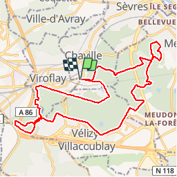
22 km

Max alt
188 m

Uphill gradient
280 m
Km-Effort
25 km

Min alt
97 m

Downhill gradient
280 m
Boucle
Yes
Creation date :
2016-12-29 00:00:00.0
Updated on :
2016-12-29 00:00:00.0
1h41
Difficulty : Easy

FREE GPS app for hiking
 SityTrail
IGN / Geographical institutes
SityTrail Plus
The world is yours!
About
Trail Mountain bike of 22 km to be discovered at Ile-de-France, Hauts-de-Seine, Chaville. This trail is proposed by mrioux.
Description
Petit circuit de VTT très roulant, chemin et route pas vraiment du VTT. La seul difficulté, un peu de dénivelé au début ! Superbe descente entre la N12 et la D56 !


Positioning
Country:
France
Region :
Ile-de-France
Department/Province :
Hauts-de-Seine
Municipality :
Chaville
Location:
Unknown
Start:(Dec)
Start:(UTM)
440295 ; 5405596 (31U) N.
Comments