Trail Winter sports Lausanne - Lausanne-Yverdon (parcours inédit) - 1/4 - Photo

Lausanne-Yverdon (parcours inédit) - 1/4

 Romrando
Romrando

User

© OpenStreetMap contributors
Length
Length
28 km
Max alt
Max alt
875 m
Uphill gradient
Uphill gradient
373 m
Km-Effort
Km-Effort  
34 km
Min alt
Min alt
437 m
Downhill gradient
Downhill gradient
749 m
Boucle
Boucle
No
Creation date :
2014-12-11 00:00:00.0
Updated on :
2014-12-11 00:00:00.0

(0 Reviews)

Winter sports
Winter sports
--
Difficulty : Unknown

Scan this QR Code to open this trail in the SityTrail application

FREE GPS app for hiking

Logo SityTrail SityTrail

IGN / Geographical institutes

Download SityTrail from the App Store Download SityTrail from Google Play

Logo SityTrail SityTrail World

The world is yours!

Download SityTrail from the App Store Download SityTrail from Google Play Download SityTrail on Huawei AppGallery

About

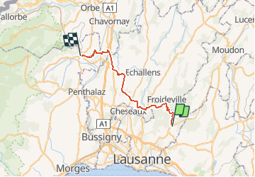
Trail Winter sports of 28 km to be discovered at Vaud, District de Lausanne, Lausanne. This trail is proposed by Romrando.

Description

Source:geocities.com/romrando

Longue (80 km) mais remarquable randonnée aux multiples facettes et ambiances. Des champs du Gros de Vaud, par les gorges sauvages jusqu''aux crêtes dénudées du Jura.

Partie no 1/4 (Lausanne-La Sarraz)

Du Chalet à Gobet suivre le chemin qui longe la plaine de Mauvernay par l''est puis remonte quelque peu pour rejoindre une petite route que l''on suit vers la gauche en descente jusqu''à une croisée. Continuer tout droit et suivre alors un chemin vers le N, passer un carrefour (abri forestier) et poursuivre tout droit le chemin jusqu''à une grande épingle qui ramène dans le fond des gorges du Talent.

Suivre la gorge en agréable descente jusqu''à Montheron et son abbaye. Par la route on gagne facilement Cugy puis Morrens.

Au centre du village suivre la direction d''Echallens sur 500m puis au premier virage prendre à gauche une petite route qui descend sur Etagnières.

On traverse le village et par une petite route on rejoint à travers bois Bioley-Orjulaz. Continuer toujours tout droit par un chemin agricole jusqu''à St-Barthélemy.

Traverser le village vers la gauche et juste avant la rivière prendre un chemin vers la droite qui contourne le château et rejoint Oulens.

Par la route sur 2.5 km direction Bavois, on passe sous l''autoroute. 500m après à la sortie du bois, descendre à gauche par un chemin puis à nouveau à gauche par un mauvais chemin assez raide pour rejoindre une croisée.

Prendre vers la gauche et sortir du bois, laisser un cabanon à sa gauche et suivre la lisière jusqu''à son fond (très mal marqué, souvent caché par de hautes herbes). On s''engage dans le bois par un sentier agréable (belle descente). A une croisée prendre à droite. On franchit alors la voie ferrée au-dessus d''un tunnel puis une descente mène à Entreroches.

Suivre la route cantonale à gauche sur 300m puis prendre à gauche un mauvais chemin (>>>) qui grimpe au Mormont.

Vers l''W on rejoint une petite route qui mène à La Sarraz.

La partie difficile du Mormont peut être simplement évitée en suivant la route sur Orny puis La Sarraz.


Elevation profile

Positioning

Country:
Switzerland
Region :
Vaud
Department/Province :
District de Lausanne
Municipality :
Lausanne
Location:
Unknown
Start:(UTM)
323191 ; 5159498 (32T) N.

Trails nearby

Trail On foot Lausanne - Le chemin des fontaines des Bois du Jorat - Photo
On foot
PRO

On foot

Easy
Lausanne, Vaud, District de Lausanne, Switzerland
12 km | 15.1 km-effort
3h 25min
Yes
Trail On foot Epalinges - Sur les traces du renard - Photo
On foot
PRO

On foot

Easy
Epalinges, Vaud, District de Lausanne, Switzerland
8 km | 9.5 km-effort
2h 9min
No
Trail Winter sports Morrens - Au boulot à ski, aller-retour, déc 2009 - Photo
Winter sports
marc

Winter sports

Very easy
Morrens, Vaud, District du Gros-de-Vaud, Switzerland
16.3 km | 21 km-effort
3h 0min
Yes
Trail Car Lausanne - Tour 25 - Photo
Car
altercom

Car

Lausanne, Vaud, District de Lausanne, Switzerland
23 km | 28 km-effort
4h 59min
No
Trail Other activity Lausanne - froideveille - Photo
Other activity
anselmo

Other activity

Very easy
Lausanne, Vaud, District de Lausanne, Switzerland
4.7 km | 5.6 km-effort
Unknown
No
Trail Other activity Le Mont-sur-Lausanne - Cadev - Photo
Other activity
Fattet

Other activity

Very easy
Le Mont-sur-Lausanne, Vaud, District de Lausanne, Switzerland
4.2 km | 5.7 km-effort
Unknown
No
Trail Via ferrata Froideville - Coursse du gros-de-vaud - Photo
Via ferrata
ludovicpeguiron

Via ferrata

Very easy
Froideville, Vaud, District du Gros-de-Vaud, Switzerland
6.2 km | 7.6 km-effort
Unknown
No
Trail Other activity Pully - Pully - Vevey 1 - Photo
Other activity
pierrepraz

Other activity

Very easy
Pully, Vaud, District de Lavaux-Oron, Switzerland
21 km | 29 km-effort
Unknown
No
Trail Other activity Cugy - Cugy - Photo
Other activity
chrispot

Other activity

Very easy
Cugy, Vaud, District du Gros-de-Vaud, Switzerland
7.8 km | 10.1 km-effort
Unknown
Yes


Close
My subscriptions