


Baou de st jeannet

slivoide
User
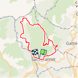

Length
15 km

Max alt
872 m

Uphill gradient
770 m
Km-Effort
25 km

Min alt
363 m

Downhill gradient
765 m
Boucle
Yes
Creation date :
2014-12-10 00:00:00.0
Updated on :
2014-12-10 00:00:00.0
2h30
Difficulty : Medium

FREE GPS app for hiking
 SityTrail
IGN / Geographical institutes
SityTrail Plus
The world is yours!
About
Trail Running of 15 km to be discovered at Provence-Alpes-Côte d'Azur, Maritime Alps, Saint-Jeannet. This trail is proposed by slivoide.
Positioning
Country:
France
Region :
Provence-Alpes-Côte d'Azur
Department/Province :
Maritime Alps
Municipality :
Saint-Jeannet
Location:
Unknown
Start:(Dec)
Start:(UTM)
350128 ; 4845568 (32T) N.
Comments