


Stieregg, Rots Gufer, Schreckhornhütte

pnoth
User
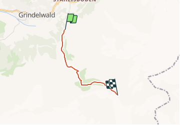

Length
6 km

Max alt
2300 m

Uphill gradient
1041 m
Km-Effort
16.8 km

Min alt
1356 m

Downhill gradient
130 m
Boucle
No
Creation date :
2014-12-11 00:00:00.0
Updated on :
2014-12-11 00:00:00.0
--
Difficulty : Unknown

FREE GPS app for hiking
 SityTrail
IGN / Geographical institutes
SityTrail Plus
The world is yours!
About
Trail Other activity of 6 km to be discovered at Bern, Interlaken-Oberhasli administrative district, Grindelwald. This trail is proposed by pnoth.
Description
English: http://www.noth.ch/h0204_e.html
Français: http://www.noth.ch/h0204_f.html
Deutsch: http://www.noth.ch/h0204_d.html
Positioning
Country:
Switzerland
Region :
Bern
Department/Province :
Interlaken-Oberhasli administrative district
Municipality :
Grindelwald
Location:
Unknown
Start:(Dec)
Start:(UTM)
427736 ; 5163052 (32T) N.
Comments