


bourre24413

CRCL
User
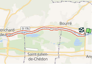

Length
9.1 km

Max alt
69 m

Uphill gradient
52 m
Km-Effort
9.8 km

Min alt
57 m

Downhill gradient
53 m
Boucle
Yes
Creation date :
2014-12-10 00:00:00.0
Updated on :
2014-12-10 00:00:00.0
2h03
Difficulty : Easy

FREE GPS app for hiking
 SityTrail
IGN / Geographical institutes
SityTrail Plus
The world is yours!
About
Trail Nordic walking of 9.1 km to be discovered at Centre-Loire Valley, Loir-et-Cher, Angé. This trail is proposed by CRCL.
Photos


Positioning
Country:
France
Region :
Centre-Loire Valley
Department/Province :
Loir-et-Cher
Municipality :
Angé
Location:
Unknown
Start:(Dec)
Start:(UTM)
367007 ; 5244576 (31T) N.
Comments