


2013 04 21 Ceyreste

lboubis
User
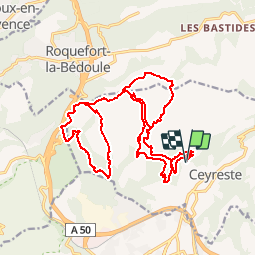

Length
30 km

Max alt
483 m

Uphill gradient
1028 m
Km-Effort
44 km

Min alt
101 m

Downhill gradient
1031 m
Boucle
Yes
Creation date :
2014-12-10 00:00:00.0
Updated on :
2014-12-10 00:00:00.0
2h48
Difficulty : Difficult

FREE GPS app for hiking
 SityTrail
IGN / Geographical institutes
SityTrail Plus
The world is yours!
About
Trail Mountain bike of 30 km to be discovered at Provence-Alpes-Côte d'Azur, Bouches-du-Rhône, Ceyreste. This trail is proposed by lboubis.
Positioning
Country:
France
Region :
Provence-Alpes-Côte d'Azur
Department/Province :
Bouches-du-Rhône
Municipality :
Ceyreste
Location:
Unknown
Start:(Dec)
Start:(UTM)
713541 ; 4788773 (31T) N.
Comments