


autour monastère

svp59
User

Length
11.7 km

Max alt
167 m

Uphill gradient
278 m
Km-Effort
15.4 km

Min alt
49 m

Downhill gradient
271 m
Boucle
Yes
Creation date :
2014-12-10 00:00:00.0
Updated on :
2014-12-10 00:00:00.0
3h05
Difficulty : Medium

FREE GPS app for hiking
 SityTrail
IGN / Geographical institutes
SityTrail Plus
The world is yours!
About
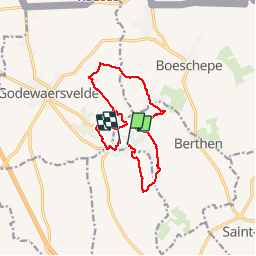
Trail Walking of 11.7 km to be discovered at Hauts-de-France, Nord, Berthen. This trail is proposed by svp59.


Positioning
Country:
France
Region :
Hauts-de-France
Department/Province :
Nord
Municipality :
Berthen
Location:
Unknown
Start:(Dec)
Start:(UTM)
476752 ; 5625732 (31U) N.
Comments