


2013 05 01

lboubis
User
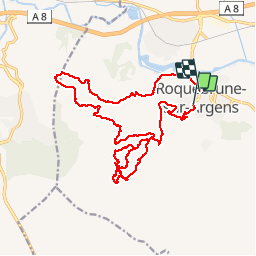

Length
23 km

Max alt
247 m

Uphill gradient
707 m
Km-Effort
33 km

Min alt
10 m

Downhill gradient
730 m
Boucle
No
Creation date :
2014-12-10 00:00:00.0
Updated on :
2014-12-10 00:00:00.0
4h08
Difficulty : Medium

FREE GPS app for hiking
 SityTrail
IGN / Geographical institutes
SityTrail Plus
The world is yours!
About
Trail Mountain bike of 23 km to be discovered at Provence-Alpes-Côte d'Azur, Var, Roquebrune-sur-Argens. This trail is proposed by lboubis.
Positioning
Country:
France
Region :
Provence-Alpes-Côte d'Azur
Department/Province :
Var
Municipality :
Roquebrune-sur-Argens
Location:
Unknown
Start:(Dec)
Start:(UTM)
308528 ; 4812550 (32T) N.
Comments
exceptionnel. beau tracés. et c'est un savoyard qui te le dit.:-)