Trail Walking Sessenheim - Sessenheim - Photo
© OpenStreetMap contributors
Length
Length
19.6 km
Max alt
Max alt
132 m
Uphill gradient
Uphill gradient
117 m
Km-Effort
Km-Effort  
21 km
Min alt
Min alt
114 m
Downhill gradient
Downhill gradient
117 m
Boucle
Boucle
Yes
Creation date :
2014-12-10 00:00:00.0
Updated on :
2014-12-10 00:00:00.0

(1 Reviews)

Walking
Walking
6h15
Difficulty : Difficult

Scan this QR Code to open this trail in the SityTrail application

FREE GPS app for hiking

Logo SityTrail SityTrail

IGN / Geographical institutes

Download SityTrail from the App Store Download SityTrail from Google Play

Logo SityTrail SityTrail Plus

The world is yours!

Download SityTrail from the App Store Download SityTrail from Google Play Download SityTrail on Huawei AppGallery

About

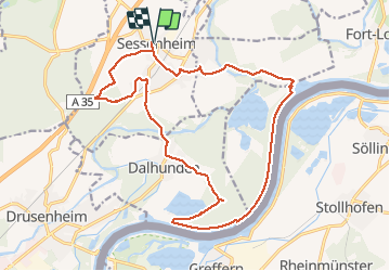
Trail Walking of 19.6 km to be discovered at Grand Est, Bas-Rhin, Sessenheim. This trail is proposed by VacheKiri67.

Description

Distance 19,6km - Dénivelée 110m. Balisage : aucun. Faite le 01/05/2013 en 6h15 (dont 0h45 de pause) avec notre fils de 8 ans. D'après : Guide Rother Alsace N°15 page 62 : Depuis Sessenheim le long du Rhin.
Mais parcouru en sens inverse. Surys Gut est un chemin privé donc détour à faire par Redoutenkopf.

Elevation profile

Photos

Positioning

Country:
France
Region :
Grand Est
Department/Province :
Bas-Rhin
Municipality :
Sessenheim
Location:
Unknown
Start:(UTM)
425537 ; 5405648 (32U) N.

Comments

Please log in to post a review or rate the element


Le parcours longe malheureusement des routes qui même si elles sont peu fréquentées empêchent de s'évader pleinement !


Close
My subscriptions