


Chardonne

Marginal
User
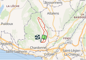

Length
7.6 km

Max alt
894 m

Uphill gradient
276 m
Km-Effort
11.3 km

Min alt
745 m

Downhill gradient
279 m
Boucle
Yes
Creation date :
2014-12-11 00:00:00.0
Updated on :
2014-12-11 00:00:00.0
--
Difficulty : Unknown

FREE GPS app for hiking
 SityTrail
IGN / Geographical institutes
SityTrail Plus
The world is yours!
About
Trail Other activity of 7.6 km to be discovered at Vaud, District de la Riviera-Pays-d’Enhaut, Chardonne. This trail is proposed by Marginal.
Description
Parcours VTT à Chardonne
Positioning
Country:
Switzerland
Region :
Vaud
Department/Province :
District de la Riviera-Pays-d’Enhaut
Municipality :
Chardonne
Location:
Unknown
Start:(Dec)
Start:(UTM)
333561 ; 5149901 (32T) N.
Comments