


Marseille -cassis- route

mapomme
User
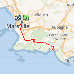

Length
49 km

Max alt
336 m

Uphill gradient
876 m
Km-Effort
61 km

Min alt
1 m

Downhill gradient
877 m
Boucle
Yes
Creation date :
2014-12-10 00:00:00.0
Updated on :
2014-12-10 00:00:00.0
3h43
Difficulty : Unknown

FREE GPS app for hiking
 SityTrail
IGN / Geographical institutes
SityTrail Plus
The world is yours!
About
Trail Cycle of 49 km to be discovered at Provence-Alpes-Côte d'Azur, Bouches-du-Rhône, Marseille. This trail is proposed by mapomme.
Description
Que de la route, pas de fantaisie ...
Positioning
Country:
France
Region :
Provence-Alpes-Côte d'Azur
Department/Province :
Bouches-du-Rhône
Municipality :
Marseille
Location:
1st Arrondissement
Start:(Dec)
Start:(UTM)
693967 ; 4797213 (31T) N.
Comments