


Dauendorf

VacheKiri67
User


5h09
Difficulty : Medium

FREE GPS app for hiking
 SityTrail
IGN / Geographical institutes
SityTrail Plus
The world is yours!
About
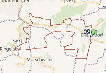
Trail Walking of 14.3 km to be discovered at Grand Est, Bas-Rhin, Dauendorf. This trail is proposed by VacheKiri67.
Description
Distance 14,3km - Dénivelée 300m. Balisage : partiellement anneau jaune - anneau rouge - anneau jaune. Faite le 04/05/2013 en 5h10 (dont 0h55 de pause) avec notre fils de 8 ans. D'après : Randonnées et histoires N°10 page 77 : Sur les collines du Val de Moder.
Attention le balisage est parfois incomplet et les chemins sont boueux par temps de pluie.
Photos


26 photos in total. Please click on a photo to see them all in the gallery.
Positioning
Comments
Uberach
Une magnifique randonnée champêtre ! A faire absolument au printemps par beau soleil lorsque les pissenlits, pâquerettes, colza et arbres fruitiers sont en fleurs. La variété est au rendez-vous : collines, panoramas, prairies, chapelles, forêt, aires de pique-nique... Par contre à éviter par temps de pluie car les sentiers sont vite très boueux.