


Remiencourt

lefrancm
User
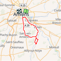

Length
35 km

Max alt
118 m

Uphill gradient
417 m
Km-Effort
40 km

Min alt
26 m

Downhill gradient
417 m
Boucle
Yes
Creation date :
2014-12-10 00:00:00.0
Updated on :
2014-12-10 00:00:00.0
2h19
Difficulty : Medium

FREE GPS app for hiking
 SityTrail
IGN / Geographical institutes
SityTrail Plus
The world is yours!
About
Trail Cycle of 35 km to be discovered at Hauts-de-France, Somme, Amiens. This trail is proposed by lefrancm.
Description
petite sortie à vélo sympa à partir d'amiens


Positioning
Country:
France
Region :
Hauts-de-France
Department/Province :
Somme
Municipality :
Amiens
Location:
Unknown
Start:(Dec)
Start:(UTM)
450111 ; 5526026 (31U) N.
Comments