


Le puit d Agnié

pocoyo
User
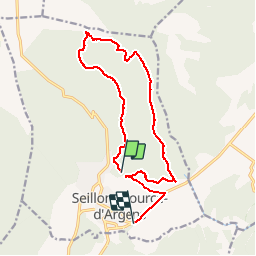

Length
16.1 km

Max alt
520 m

Uphill gradient
283 m
Km-Effort
19.9 km

Min alt
273 m

Downhill gradient
307 m
Boucle
No
Creation date :
2014-12-10 00:00:00.0
Updated on :
2014-12-10 00:00:00.0
3h52
Difficulty : Easy

FREE GPS app for hiking
 SityTrail
IGN / Geographical institutes
SityTrail Plus
The world is yours!
About
Trail Walking of 16.1 km to be discovered at Provence-Alpes-Côte d'Azur, Var, Seillons-Source-d'Argens. This trail is proposed by pocoyo.
Description
Randonnée pédestre à Seillons Source d'Argens de 13 km (3h30) avec un dénivelé de 310m
Positioning
Country:
France
Region :
Provence-Alpes-Côte d'Azur
Department/Province :
Var
Municipality :
Seillons-Source-d'Argens
Location:
Unknown
Start:(Dec)
Start:(UTM)
733270 ; 4820930 (31T) N.
Comments