Trail Walking Fréjus - VVA 2109 Etangs de Villepey - Photo

VVA 2109 Etangs de Villepey

© OpenStreetMap contributors
Length
Length
17 km
Max alt
Max alt
135 m
Uphill gradient
Uphill gradient
199 m
Km-Effort
Km-Effort  
19.6 km
Min alt
Min alt
-1 m
Downhill gradient
Downhill gradient
198 m
Boucle
Boucle
Yes
Creation date :
2014-12-10 00:00:00.0
Updated on :
2014-12-10 00:00:00.0

(1 Reviews)

Walking
Walking
4h13
Difficulty : Easy

Scan this QR Code to open this trail in the SityTrail application

FREE GPS app for hiking

Logo SityTrail SityTrail

IGN / Geographical institutes

Download SityTrail from the App Store Download SityTrail from Google Play

Logo SityTrail SityTrail World

The world is yours!

Download SityTrail from the App Store Download SityTrail from Google Play Download SityTrail on Huawei AppGallery

About

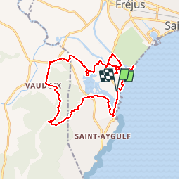
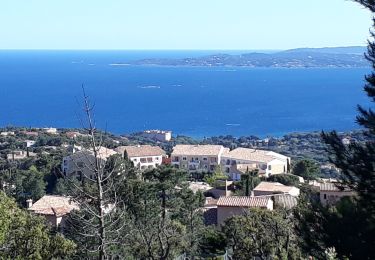
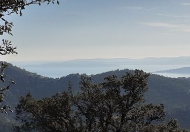
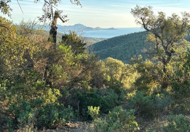
Trail Walking of 17 km to be discovered at Provence-Alpes-Côte d'Azur, Var, Fréjus. This trail is proposed by jmheydorff.

Description

Tour des etangs, et bord de l'Argens.
Pkg possibles en bord de mer, payant en été;  ou Pkg prêt du pont sur l'Argens, ou sur la d7 , au niveau du centre de ski nautique.
17 kms  150 m 4h30

Elevation profile

Positioning

Country:
France
Region :
Provence-Alpes-Côte d'Azur
Department/Province :
Var
Municipality :
Fréjus
Location:
Unknown
Start:(UTM)
316153 ; 4807963 (32T) N.

Comments

Please log in to post a review or rate the element


tres bien


Trails nearby

Trail Walking Fréjus - Etang de Villepey - Photo
Walking
marmotte83

Walking

Very easy
(2)
Fréjus, Provence-Alpes-Côte d'Azur, Var, France
6.5 km | 7 km-effort
3h 4min
Yes
Trail Walking Roquebrune-sur-Argens - 200526 Les Issambres - Photo
Walking
bebenoit83

Walking

Medium
(1)
Roquebrune-sur-Argens, Provence-Alpes-Côte d'Azur, Var, France
8.3 km | 12.2 km-effort
2h 33min
Yes
Trail Walking Roquebrune-sur-Argens - la Gaillarde  - Photo
Walking
GUIDE
nadinebondoux

Walking

Easy
Roquebrune-sur-Argens, Provence-Alpes-Côte d'Azur, Var, France
6.5 km | 10.1 km-effort
1h 59min
Yes
Trail Mountain bike Fréjus - Roc Odyssée 2015 - Photo
Mountain bike
Dominick

Mountain bike

Medium
(1)
Fréjus, Provence-Alpes-Côte d'Azur, Var, France
37 km | 47 km-effort
3h 55min
No
Trail Walking Roquebrune-sur-Argens - Gaillarde - Photo
Walking
erikr

Walking

Easy
(2)
Roquebrune-sur-Argens, Provence-Alpes-Côte d'Azur, Var, France
8.3 km | 12.7 km-effort
2h 40min
Yes
Trail Mountain bike Fréjus - Tour des Petites Maures - Photo
Mountain bike
barberou

Mountain bike

Very easy
(2)
Fréjus, Provence-Alpes-Côte d'Azur, Var, France
40 km | 52 km-effort
Unknown
Yes
Trail Walking Fréjus - petites maures  - Photo
Walking
Matamimi

Walking

Difficult
Fréjus, Provence-Alpes-Côte d'Azur, Var, France
12.9 km | 17.5 km-effort
4h 47min
No
Trail Walking Roquebrune-sur-Argens - Col du Bougnon : la Garonnette - Photo
Walking
ETMU5496

Walking

Medium
Roquebrune-sur-Argens, Provence-Alpes-Côte d'Azur, Var, France
17.6 km | 28 km-effort
6h 16min
Yes
Trail Walking Saint-Raphaël - sentier des douaniers Géologie/ Botanique - Photo
Walking
boulinevelyne

Walking

Medium
Saint-Raphaël, Provence-Alpes-Côte d'Azur, Var, France
6 km | 6.8 km-effort
1h 32min
No


Close
My subscriptions