


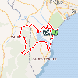
VVA 2109 Etangs de Villepey

jmheydorff
User

Length
17 km

Max alt
135 m

Uphill gradient
199 m
Km-Effort
19.6 km

Min alt
-1 m

Downhill gradient
198 m
Boucle
Yes
Creation date :
2014-12-10 00:00:00.0
Updated on :
2014-12-10 00:00:00.0
4h13
Difficulty : Easy

FREE GPS app for hiking
 SityTrail
IGN / Geographical institutes
SityTrail Plus
The world is yours!
About
Trail Walking of 17 km to be discovered at Provence-Alpes-Côte d'Azur, Var, Fréjus. This trail is proposed by jmheydorff.
Description
Tour des etangs, et bord de l'Argens.
Pkg possibles en bord de mer, payant en été; ou Pkg prêt du pont sur l'Argens, ou sur la d7 , au niveau du centre de ski nautique.
17 kms 150 m 4h30
Positioning
Country:
France
Region :
Provence-Alpes-Côte d'Azur
Department/Province :
Var
Municipality :
Fréjus
Location:
Unknown
Start:(Dec)
Start:(UTM)
316153 ; 4807963 (32T) N.
Comments
tres bien