


la bballade de la loue

msergio
User
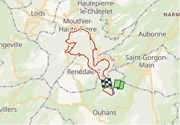

Length
16.1 km

Max alt
785 m

Uphill gradient
686 m
Km-Effort
25 km

Min alt
378 m

Downhill gradient
692 m
Boucle
Yes
Creation date :
2014-12-10 00:00:00.0
Updated on :
2014-12-10 00:00:00.0
4h21
Difficulty : Medium

FREE GPS app for hiking
 SityTrail
IGN / Geographical institutes
SityTrail Plus
The world is yours!
About
Trail Walking of 16.1 km to be discovered at Bourgogne-Franche-Comté, Doubs, Ouhans. This trail is proposed by msergio.
Description
randonnée incontournable à Ouhant
Photos


47 photos in total. Please click on a photo to see them all in the gallery.


Positioning
Country:
France
Region :
Bourgogne-Franche-Comté
Department/Province :
Doubs
Municipality :
Ouhans
Location:
Unknown
Start:(Dec)
Start:(UTM)
294678 ; 5209446 (32T) N.
Comments