


Vierge

mitty
User
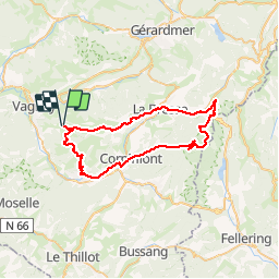

Length
48 km

Max alt
1076 m

Uphill gradient
1182 m
Km-Effort
64 km

Min alt
465 m

Downhill gradient
1185 m
Boucle
Yes
Creation date :
2014-12-10 00:00:00.0
Updated on :
2014-12-10 00:00:00.0
3h37
Difficulty : Unknown

FREE GPS app for hiking
 SityTrail
IGN / Geographical institutes
SityTrail Plus
The world is yours!
About
Trail Cycle of 48 km to be discovered at Grand Est, Vosges, Basse-sur-le-Rupt. This trail is proposed by mitty.
Description
Vierge
Positioning
Country:
France
Region :
Grand Est
Department/Province :
Vosges
Municipality :
Basse-sur-le-Rupt
Location:
Unknown
Start:(Dec)
Start:(UTM)
332472 ; 5317893 (32T) N.
Comments