Trail Mountain bike Verneuil-l'Étang - VTT autour de Verneuil-l'Étang - Photo

VTT autour de Verneuil-l'Étang

 tracegps
tracegps

User

© OpenStreetMap contributors
Length
Length
9.9 km
Max alt
Max alt
116 m
Uphill gradient
Uphill gradient
90 m
Km-Effort
Km-Effort  
11.1 km
Min alt
Min alt
75 m
Downhill gradient
Downhill gradient
90 m
Boucle
Boucle
Yes
Creation date :
2014-12-10 00:00:00.0
Updated on :
2014-12-10 00:00:00.0

(1 Reviews)

Mountain bike
Mountain bike
45m
Difficulty : Easy

Scan this QR Code to open this trail in the SityTrail application

FREE GPS app for hiking

Logo SityTrail SityTrail

IGN / Geographical institutes

Download SityTrail from the App Store Download SityTrail from Google Play

Logo SityTrail SityTrail World

The world is yours!

Download SityTrail from the App Store Download SityTrail from Google Play Download SityTrail on Huawei AppGallery

About

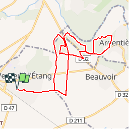
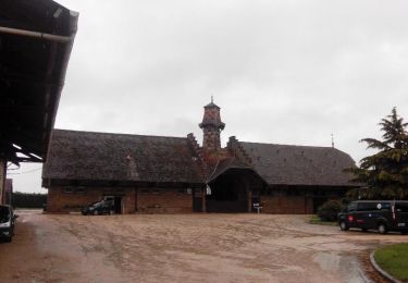
Trail Mountain bike of 9.9 km to be discovered at Ile-de-France, Seine-et-Marne, Verneuil-l'Étang. This trail is proposed by tracegps.

Description

Départ du parking de la rue de Lamartine. Parcours facile qui permet de découvrir les alentours de Verneuil-l'église.

Elevation profile

Photos

Positioning

Country:
France
Region :
Ile-de-France
Department/Province :
Seine-et-Marne
Municipality :
Verneuil-l'Étang
Location:
Unknown
Start:(UTM)
487735 ; 5387688 (31U) N.

Comments

Please log in to post a review or rate the element


Attention ! Édition trop ancienne. Le parcourt ne peut plus se faire tel que. Propriété privée, végétation dense bloquant le passage, ...


Trails nearby

Trail Walking Chaumes-en-Brie - Chaumes-en-Brie SR190323 CRI040623 300922fmg - Photo
Walking
fmg

Walking

Very difficult
(1)
Chaumes-en-Brie, Ile-de-France, Seine-et-Marne, France
22 km | 26 km-effort
5h 48min
Yes
Trail Walking Verneuil-l'Étang - Le tour du grand Paris via le GR1 Etape 12 Verneuil l'Etang- Melun - Photo
Walking
chessyca

Walking

Medium
Verneuil-l'Étang, Ile-de-France, Seine-et-Marne, France
36 km | 40 km-effort
6h 55min
No
Trail Walking Chaumes-en-Brie - Châteaux autour de Chaumes en Brie - Photo
Walking
chessyca

Walking

Easy
Chaumes-en-Brie, Ile-de-France, Seine-et-Marne, France
26 km | 28 km-effort
6h 21min
Yes
Trail Walking Ozouer-le-Voulgis - autour? - Photo
Walking
Cesaria

Walking

Very easy
Ozouer-le-Voulgis, Ile-de-France, Seine-et-Marne, France
6.3 km | 7.1 km-effort
3h 16min
No
Trail Walking Chaumes-en-Brie - SityTrail - Chaumes sous les Tropiques - Photo
Walking
dmatignon

Walking

Easy
(1)
Chaumes-en-Brie, Ile-de-France, Seine-et-Marne, France
11.3 km | 13 km-effort
3h 25min
Yes
Trail Walking Chaumes-en-Brie - Autour de CHAUMES en BRIE - Photo
Walking
pikibangi

Walking

Medium
Chaumes-en-Brie, Ile-de-France, Seine-et-Marne, France
21 km | 23 km-effort
5h 0min
Yes
Trail Walking Chaumes-en-Brie - Chaumes'Yerres - Photo
Walking
PatRando

Walking

Medium
Chaumes-en-Brie, Ile-de-France, Seine-et-Marne, France
23 km | 26 km-effort
5h 35min
Yes
Trail Walking Chaumes-en-Brie - Chaumes en Brie, circuit n° 1 - Photo
Walking
tracegps

Walking

Medium
(1)
Chaumes-en-Brie, Ile-de-France, Seine-et-Marne, France
10.7 km | 12.2 km-effort
2h 40min
Yes
Trail Walking Chaumes-en-Brie - ouest de forest 2011-11-27 17h41m03 - Photo
Walking
ajp77

Walking

Medium
(1)
Chaumes-en-Brie, Ile-de-France, Seine-et-Marne, France
6 km | 6.6 km-effort
1h 57min
No


Close
My subscriptions