Trail Walking Puylaurens - Boucle de Saint Sébastien - Puylaurens - Photo

Boucle de Saint Sébastien - Puylaurens

 tracegps
tracegps

User

© OpenStreetMap contributors
Length
Length
12 km
Max alt
Max alt
324 m
Uphill gradient
Uphill gradient
322 m
Km-Effort
Km-Effort  
16.3 km
Min alt
Min alt
154 m
Downhill gradient
Downhill gradient
325 m
Boucle
Boucle
Yes
Creation date :
2014-12-10 00:00:00.0
Updated on :
2014-12-10 00:00:00.0

(0 Reviews)

Walking
Walking
3h30
Difficulty : Medium

Scan this QR Code to open this trail in the SityTrail application

FREE GPS app for hiking

Logo SityTrail SityTrail

IGN / Geographical institutes

Download SityTrail from the App Store Download SityTrail from Google Play

Logo SityTrail SityTrail World

The world is yours!

Download SityTrail from the App Store Download SityTrail from Google Play Download SityTrail on Huawei AppGallery

About

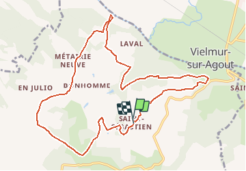
Trail Walking of 12 km to be discovered at Occitania, Tarn, Puylaurens. This trail is proposed by tracegps.

Description

Départ du hameau de St Sébastien. A Puylaurens prendre la route de Vielmur sur Agout. Le circuit d'environ 12,5 Km offre des points de vue bucoliques sur la vallée de l'Agout et les collines du Pays de Cocagne.

Elevation profile

Photos

Positioning

Country:
France
Region :
Occitania
Department/Province :
Tarn
Municipality :
Puylaurens
Location:
Unknown
Start:(UTM)
424862 ; 4828784 (31T) N.

Trails nearby

Trail Walking Puylaurens - Boucle d'En Guibaud - Puylaurens - Photo
Walking
tracegps

Walking

Difficult
(1)
Puylaurens, Occitania, Tarn, France
14.5 km | 19.3 km-effort
3h 40min
Yes
Trail Walking Puylaurens - Le grand 8 de Montaut - Photo
Walking
Emmanuelle Benoit

Walking

Medium
Puylaurens, Occitania, Tarn, France
8.3 km | 11.5 km-effort
2h 57min
Yes
Trail Walking Puylaurens - Puylaurens  - Photo
Walking
jpp2caunes

Walking

Difficult
Puylaurens, Occitania, Tarn, France
13.5 km | 18.1 km-effort
3h 50min
Yes
Trail Walking Cuq - randonnée avec club maman - Photo
Walking
sandymocko

Walking

Medium
Cuq, Occitania, Tarn, France
14.1 km | 18.7 km-effort
3h 51min
Yes
Trail Running Vielmur-sur-Agout - Les Eoliennes de Cuq Serviès - Vielmur sur Agout - Photo
Running
tracegps

Running

Difficult
Vielmur-sur-Agout, Occitania, Tarn, France
18.9 km | 22 km-effort
1h 40min
Yes
Trail Mountain bike Vielmur-sur-Agout - Les Eoliennes de Cuq Serviès - Vielmur sur Agout - Photo
Mountain bike
tracegps

Mountain bike

Medium
Vielmur-sur-Agout, Occitania, Tarn, France
18.9 km | 22 km-effort
1h 15min
Yes
Trail Walking Puylaurens - puylaurens 2023 - Photo
Walking
Frayssinet

Walking

Very difficult
Puylaurens, Occitania, Tarn, France
22 km | 28 km-effort
6h 25min
Yes
Trail Walking Sémalens - Sentier des amoureux Semalens - Photo
Walking
tabouelle

Walking

Very easy
Sémalens, Occitania, Tarn, France
8.7 km | 9.3 km-effort
2h 20min
Yes
Trail Walking Puylaurens - Puylaurens - Photo
Walking
philibar

Walking

Easy
Puylaurens, Occitania, Tarn, France
10.2 km | 13.7 km-effort
3h 5min
Yes


Close
My subscriptions